The story of the 2005 cyclones in the Cook Islands
CYCLONES TIMELINE 1. Meena, 1st Feb 2. Nancy, 10th Feb 3. Olaf, 14 Feb 4. Percy, 25th Feb 5. Rae, 4th March
The impact of Percy - the fourth cyclone in as many weeks - was felt deeply on the remote Northern Group islands of Nassau and Pukapuka for several years. The islands received an almost direct hit when the cyclone was at its strongest. It was classified at the time as a category 4 to 5 cyclone on a scale where 5 is the most severe. The Joint Typhoon Warning Centre in Fiji estimated sustained winds of 115 knots (212 kph, 132 mph). And in the aftermath, there were fears the islands would have to be evacuated or even abandoned
CYCLONE PERCY
The destruction caused to Pukapuka by Cyclone Percy. These photographs were taken by the crew of a New Zealand Air Force 'Orion' which overflew the island a few days after the cyclone struck
The remoteness of the islands meant that reports from them were few and far between. Even the Cook Islands government nearly 1600 kms (1,000 miles) south in Rarotonga had difficulty finding out what had happened. TVNZ (Television New Zealand) was the only broadcaster to visit Pukapuka in the aftermath. These pictures are taken from that report and published here exclusively with permission of TVNZ One News
Only 10 per cent of houses on Pukapuka survived intact. Traditional homes were washed away. On Nassau, 90 per cent of the modern structures were damaged; all thatched buildings were destroyed. A concerted effort to rebuild took more than four years, but the remoteness of the two islands made work a logistical nightmare. And even now signs remain of the fateful day the cyclone struck
Water supplies were a major problem after the cyclone. Wells were contaminated and down spouts used for collecting rain were destroyed. Fresh water was flown in and the Government of French Polynesia gave the islanders a desalination plant, The taro crop - an important part of the economy - was contaminated by sea water and took years to recover
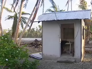
This tiny hut housed the short wave radio which was the only link with the outside world during the aftermath
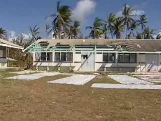
The local school was all but destroyed in the cyclone and the area around it contaminated by asbestos
This tiny hut housed the short wave radio which was the only link with the outside world during the aftermath
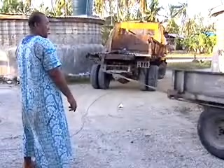
Machinery and equipment had to be brought in by boat to help the rebuilding efforts
The local school was all but destroyed in the cyclone and the area around it contaminated by asbestos
At one stage it was suggested the island might have to be abandoned altogether or that women and children should be evacuated until rebuilding was complete...but Pukapukans are made of stern stuff, and were determined to stay and work their way through the hardships
CYCLONE RAE
The one that turned into a tropical storm
The Cook Islands was put on cyclone alert again when number five - Cyclone Rae - formed, and it looked like the Islands was in for another battering. This time though, it quickly lost strength, was downgraded to a tropical storm and then moved out into the Pacific. It passed 276 kms (172 miles) south west of the capital island of Rarotonga, causing only intermittent gales and squalls. But a couple in Arorangi may have been the unluckiest islanders...they had their house destroyed by a waterspout two hours after the cyclone warnings were cancelled!
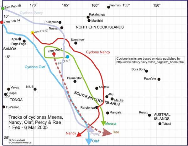
This map published by Cook Islands News shows the path of all the cyclones
If you've landed on this page and want to know how the five cyclones in five weeks began, click the button below